
This project aims to build a software that can download Sentinel-2 satellite images in batch for data analysis.
Last updated Feb 7, 2026
12
Stars
0
Forks
0
Issues
0
Stars/day
Attention Score
0
Topics
Language breakdown
Python 100.0%
▸ Files
click to expand
README
batchsat
This project aims to build a software that can download Sentinel-2 satellite images in batch for data analysis.how to install
with conda (we used miniconda3)
- download the project
- create a conda environment and run the following command:
conda install rasterio=1.3.3 geopandas=0.12.1 -c conda-forge - then, run the command:
pip install sentinelsat==1.1.1 xmltodict==0.13.0
how to use
create a csv file with the columns:
polygonid;polygonwkt;dtfrom;dtto
<uniquepolygonid0>;<polygonwkt_0>;<YYYY-mm-dd>;<YYYY-mm-dd>
.
.
.
<uniquepolygonid1>;<polygonwkt_1>;<YYYY-mm-dd>;<YYYY-mm-dd>
then, run python products.py --csv-path <pathtocsv_file>. there are other arguments, see with python products.py -h you will see that a products-polygons.csv was created.
use it as input to the next script, running: python rasters.py --csv-path <pathtooutputofproducts.py>. if everything goes ok, it will be created a folder named rasters and subfolders named with the poygons unique id. inside these subfolders you will see the downloaded raster files ready to be used.
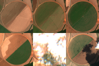
example
Example of a True Color Image 10m resolution time series from a random crop near Brasília, from 2022-06-03 to 2022-10-26.
project goals
- build a knowledge on how to collect, prepare, process and work with raster files and raster files time series
- learn digital and image processing techniques applied to satellite images
- provide a script to concurrently download images from Sentinel-2 twin satellites using computer with relatively good resources
- provide a container/microservice to scale the download satellite images in a k8s cluster
- help programmers and researchers to easily get satellite image data to make the world a better and safer place


